Design safe and affordable infrastructure

Access out-of-the-box QL D basemaps and site data to automate records research and design with more clarity. CivilGrid centralizes utility, land rights, environmental and other design data into one collaborative map to reduce rework and eliminate risk.

Design safe and affordable infrastructure

Access out-of-the-box QL D basemaps and site data to automate records research and design with more clarity. CivilGrid centralizes utility, land rights, environmental and other design data into one collaborative map to reduce rework and eliminate risk.

Design safe and affordable infrastructure

Access out-of-the-box QL D basemaps and site data to automate records research and design with more clarity. CivilGrid centralizes utility, land rights, environmental and other design data into one collaborative map to reduce rework and eliminate risk.

Watch a 2-min demo

Watch a 2-min demo

Watch a 2-min demo

Trusted by leading utilities and engineering teams

Trusted by leading utilities and engineering teams

Trusted by leading utilities and engineering teams

Rework, overruns, and risk

Every project burns weeks searching for agencies, waiting for utility records, and stitching together PDFs. Decisions are made with unidentified utilities, complex permits, unknown soil conditions, environmental risk. The result is predictable: avoidable redesigns, delays, dig-ins, and losses.

Design with confidence

Prevent costly dig-ins

Prevent costly dig-ins

Eliminate manual research to avoid expensive errors, protect people, and ensure every team trustworthy site data.

150% more agencies than 811

150% more agencies than 811

Design Affordably

Design Affordably

Design on day one, reduce rework, and limit field investigations with out-of-the-box basemaps and collaborative workflows.

88% reduction in records research time

88% reduction in records research time

Scope accurately

Scope accurately

Ensure you have the right budget and resources by  identifying conflicts and permit requirements before committing work.

75% decrease in SUE cost per project

75% decrease in SUE cost per project

The new way to plan infrastructure projects

CivilGrid automates records research by standardizing and centralizing site data sourced from utilities and agencies. All site data–utility assets, permit requirements, environmental constraints, geotechnical studies, land rights and planned work–is layered into a single collaborative map. With the full picture upfront, teams can detect conflicts earlier, scope confidently, and coordinate seamlessly with shared notes, photos, and real-time field context. The result is predictable: avoidable redesigns, delays, dig-ins, and losses.

Improve your workflows

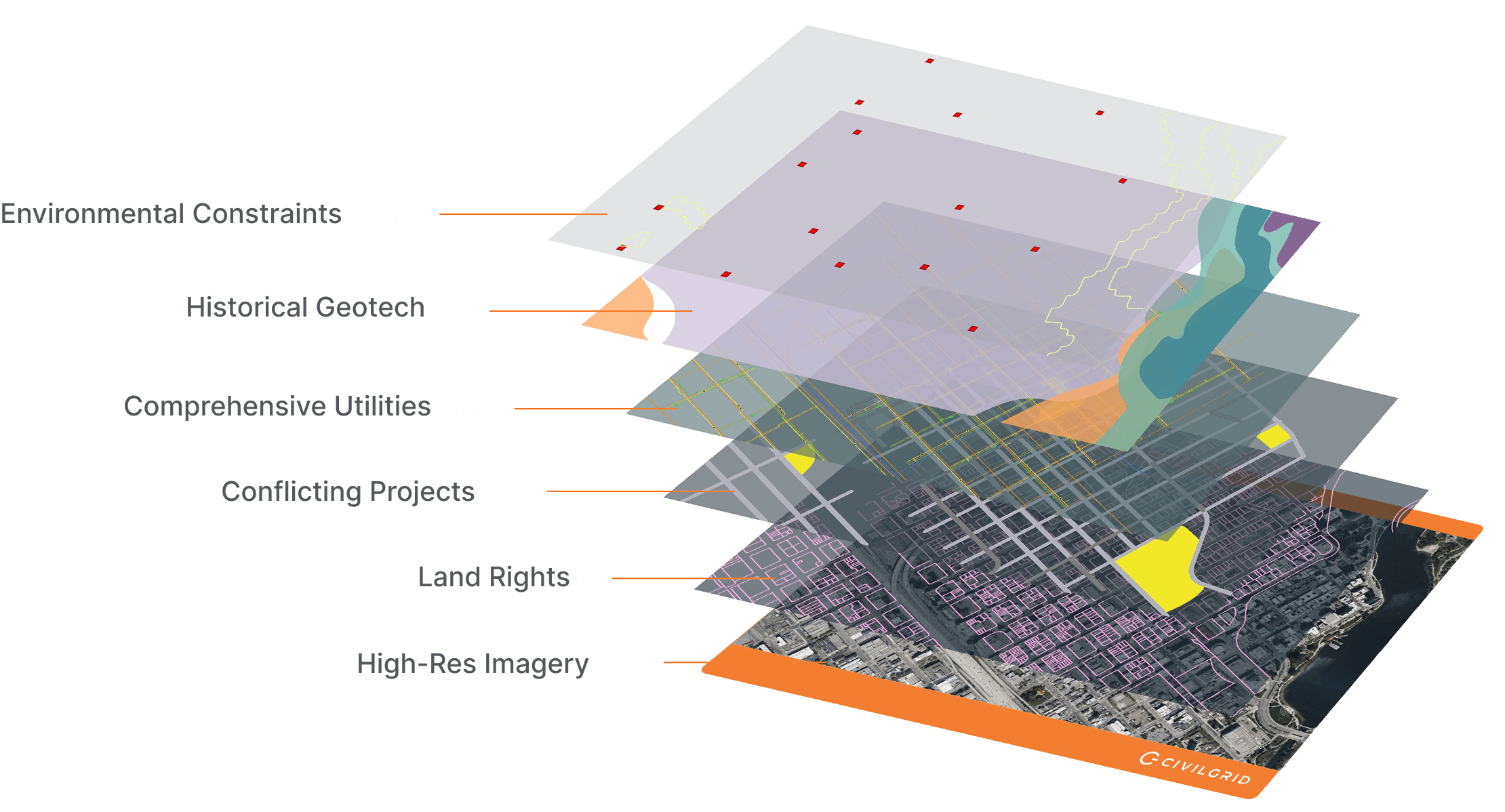
Three layers that transform how you build

Sourced Site Data

Identify all asset owners, automate records research, and centralize site data to reduce avoidable mistakes.

  • Access utility-source QL-D data with full chain-of-custody

  • Understand land rights and parcel details

  • Review geotechnical and environmental site conditions

Get Better Data

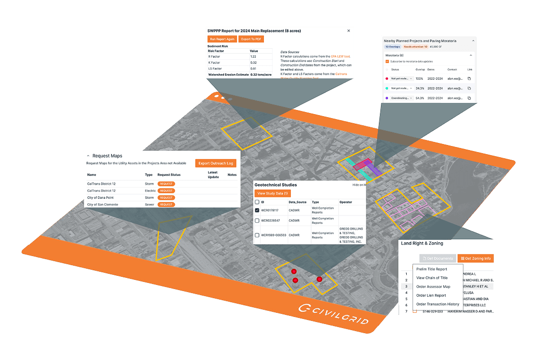
Scoping and Planning Tools

Run feasibility and conflict analysis early to avoid redesigns, reduce costs, and accelerate execution.

  • Identify permit requirements and environmental constraints upfront

  • Detect conflicts with overlapping projects and other agencies

  • Uncover conflicting projects and other hidden constraints

Modernize your approach
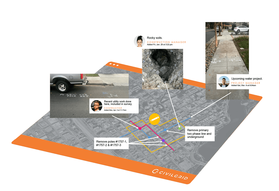
Collaborative Map

Engage, share, and design on CivilGrid’s real-time map to reduce surprises and rework.

  • Create exhibits, analyze data, and share maps in minutes

  • Enrich with field photos, notes, videos, and forms

  • Improve survey and testholes  execution with informed fieldwork

  • Export to CAD/GIS-ready formats (DWG, DGN, SHP, KMZ)

See how it works

What our customers say about us

What our customers say about us

What our customers say about us

  • “CivilGrid keeps showing its value to me every time I use it. I urge my team to use it on every proposal or project that has a utility component to be even more efficient. Their services keep getting more comprehensive over time and replaces other standalone applications we were using.”

    Matt Kamkar, QSD, PE, JD

    Principal Civil Engineer

    Underwood & Rosenblum, Inc.

  • “CivilGrid is a great tool for our pipeline projects for providing instant access to utility information during the planning and early design stages, identifying affected agencies along an alignment, and capturing field observations that aid in decision making for our designs.”

    Caisey Raines, PE

    US West Business Group Leader - Linear Infrastructure

    GHD

  • "CivilGrid's data specialists are top notch. They are always ready to answer questions, lend assistance, and make product changes to help us work better."

    Robert Lundeen

    Survey Technician

    Mark Thomas

  • “Over the past year, we’ve seen improvements in our project efficiency and overall workflow. CivilGrid’s ability to consolidate all project records and requests into a single platform has been incredibly convenient. We no longer need to juggle multiple systems or contact various agencies. Another highlight has been the exceptional responsiveness of CivilGrid’s customer support. Overall, CivilGrid has exceeded our expectations. It’s become an indispensable tool for our projects.”

    David Song, PE

    Principal

    Civiltec

  • "I recommend CivilGrid to all utilities. They are a reliable source for the vital combined utility information that doesn't exist in most areas.”

    Bill Tuttle

    VP of Engineering

    San Jose Water

Schedule a Demo

Schedule a Demo

Schedule a Demo

To learn more, give us a ring, send us an email, or grab time on our calendar

Powerful data insights.

Powerful data insights.


Powerful data insights.

Unlock the true potential of your data with our advanced analytics tools. Gain valuable insights and make informed decisions to drive your business forward.

Total Datasets

Total Datasets

Total Datasets

Hours Saved

Hours Saved

Hours Saved

Projects Completed

Projects Completed

Projects Completed

Miles of Utilities

Miles of Utilities

Miles of Utilities

Accurate site data and workflows to keep projects moving

Accurate site data and workflows to keep projects moving

Data directly from the source

Utilities data from utilities—not inferred or AI generated. CivilGrid maintains a secure chain of custody for records and documents how data was obtained.

Utilities data from utilities—not inferred or AI generated. CivilGrid maintains a secure chain of custody for records and documents how data was obtained.

Feasibility built into every project

Start assessing the feasibility of a project during portfolio planning and RFPs to accurately scope costs, resources, and timelines before committing work.

Start assessing the feasibility of a project during portfolio planning and RFPs to accurately scope costs, resources, and timelines before committing work.

Enterprise-grade trust and security

Trusted by PG&E, Atmos, Kimley-Horn and leading infrastructure teams. SOC 2 Type II certified. Over 1.6M miles of utilities mapped across 4,200+ projects.

Trusted by PG&E, Atmos, Kimley-Horn and leading infrastructure teams. SOC 2 Type II certified. Over 1.6M miles of utilities mapped across 4,200+ projects.

Talk to our team

Building the platform they wish they'd had

Building the platform they wish they'd had

Founded by former PG&E engineers and infrastructure leaders, CivilGrid's leadership team has collectively spent 70+ years inside utilities and 30+ years in civil engineering. As former operators at PG&E, National Grid, and Portland General Electric, they've managed over $1B in infrastructure projects so they understand security, data, and design challenges firsthand.

Founded by former PG&E engineers and infrastructure leaders, CivilGrid's leadership team has collectively spent 70+ years inside utilities and 30+ years in civil engineering. As former operators at PG&E, National Grid, and Portland General Electric, they've managed over $1B in infrastructure projects so they understand security, data, and design challenges firsthand.


Contact Us


Contact Us


Contact Us